Riparian HealthRiparian areas are the lush, highly diverse and productive areas that border rivers, streams, lakes and wetlands. They serve as traditional buffers between the aquatic area and the terrestrial, or upland, region. Healthy riparian areas:11
The health of riparian areas is largely determined by human disturbance. Measuring these impacts is expensive and time-consuming and is usually only performed for small areas. In the Mighty Peace watershed, the Alberta Habitat Management Society (popularly known as Cows and Fish) has completed various riparian health assessments, but only for small portions of the watershed. The results cannot be used to draw conclusions about the whole watershed.12 Computer mapping and a combination of datasets selected for their compatibility were used to estimate riparian land cover in the sub-watersheds chart below. The land cover in riparian areas associated with streams varied, ranging from 53% to 100% natural within the sub-watersheds. Areas with the greatest natural cover — such as the Slave River — have low levels of disturbance and high forest cover. In the Smoky/Wapiti and Upper Peace sub-watersheds, both agriculture and development are widespread, and riparian areas have less natural cover. |
Land Cover in Riparian Areas13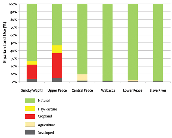 |
| © 2015 Mighty Peace Watershed Alliance | CONTACT THE ALLIANCE | NEXT PAGE: Land Use |